Cultural Asset Maps of Boston Neighborhoods
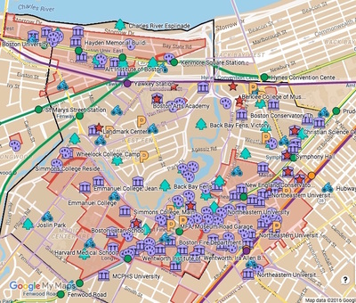
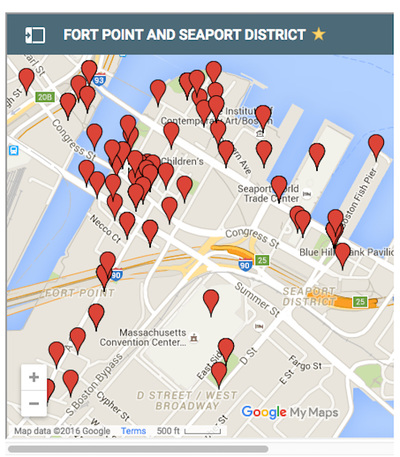
FENWAY–KENMORE FORT POINT AND SEAPORT DISTRICT
Click on map images above for downloadable maps, cultural assessment spreadsheets and more detailed information on select cultural institutions, public art, parks and the map production.
Click on map images above for downloadable maps, cultural assessment spreadsheets and more detailed information on select cultural institutions, public art, parks and the map production.
|
Cultural Asset Maps of Boston Neighborhoods
Produced by undergraduate and graduate architecture students of Wentworth Institute of Technology, the cultural asset maps help to illustrate prominent features of both the Fenway-Kenmore and the Fort Point-Seaport neighborhoods. The maps were created by participants of the Theories of Urban Design: Placemaking seminar taught by Dr. Christina Lanzl. In our research, we focused on the following categories: • Parks and open space • Notable historic and contemporary architecture • Permanent and temporary public art • Multi-modal transportation access The Cultural Assets Mapping project is an interdisciplinary, project-driven learning platform with a collaborative nature and incorporating the Institute's community partnership model into the syllabus. Wentworth students used neighborhoods of Boston as a laboratory following theoretical study. They mapped arts and cultural assets, explored the area during field trips, conducted research on historic and contemporary sites, photographed, wrote descriptions, and collectively rendered a composite cultural assets map. This project was supported by two EPIC Presidential Mini-Grants from the Wentworth Institute of Technology for the collaborative, project-based, interdisciplinary cultural assets mapping projects. |
Focus on a community or societal need
Established community non-profit organizations joined the Cultural Assets Mapping as community partners. Students had the opportunity to engage with the partners while contributing to the partners' efforts to produce printed cultural assets maps. The partners • Provided insights and resources related to their arts and cultural assets • Gave feedback on student research and outcomes • Served as community communications liaison Available to the public • Printed maps Fenway-Kenmore and Fort Point-Seaport maps, available through our community partners and at Wentworth's Beatty Hall information desk • Online downloads PDFs of the printed maps Cultural assets assessment spreadsheets 39 illustrated essays of individual sites Further information Ella Epshteyn. "Making of an EPIC Course," Wentworth Institute of Technology Blog. Feb. 3, 2016. |